
Communicating Data across Diverse Communities: Albuquerque Public Schools Approach with Empowerment, Optimization and Community Consent
by Aron Roberts, APA, and Yvonne Morales, APA
Article Background & Introduction
Effective data communication is a fundamental pillar of responsible public agency operations. It serves as a primary driver of transparency with diverse communities across the service area, fostering trust and collaboration through shared understanding. Informative and intuitive online data dashboards allow agencies to effectively demonstrate their commitment to ensuring equitable access to resources and upholding the highest standards of public accountability.
Albuquerque Public Schools (APS) has a service area of 1,230 square miles encompassing a complex patchwork of 14 different jurisdictions. These jurisdictions include two counties (Bernalillo and Sandoval), the City of Albuquerque, five villages (Corrales, Los Ranchos de Albuquerque, Tijeras, San Antonito, and Edgewood), and four different tribal communities (Sandia, Laguna, To'Hajiilee, and Isleta). The district encompasses a highly diverse landscape, transitioning from dense urban centers and sprawling suburban neighborhoods to vast rural and agricultural areas. These rural communities, often characterized by unique geographical challenges and distance from centralized school facilities, are a vital part of the district's fabric and require specialized planning and resource allocation to ensure equitable educational opportunities. The Capital Master Plan (CMP) department within APS facilitates, plans, and funds all educational and information technology facilities and equipment for the entire district. Given CMP’s duties and responsibilities, there is a need to ensure that decisions are made holistically and that all stakeholders and communities are considered. CMP has adopted public-facing online data dashboards to enable public access to key data that inform the district's decision-making.
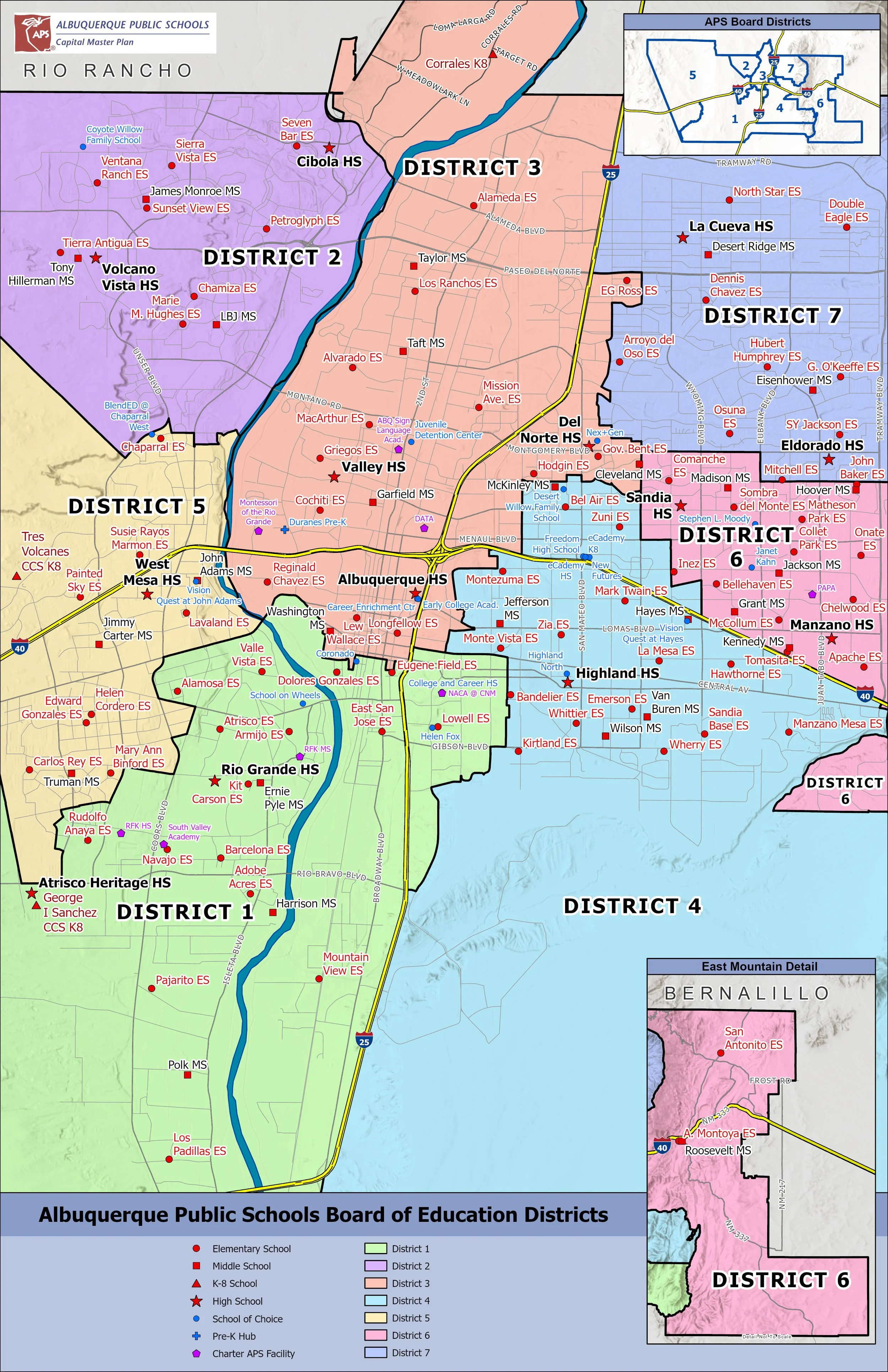
APS District Map, courtesy of Albuquerque Public Schools
Empowering Stakeholders: Forward-Facing Data
CMP is responsible for collecting and managing large volumes of data for more than 64,000 students across more than 140 facilities. With such vast quantities of data comes the task of breaking it down into manageable, digestible chunks, which is where these data dashboards play such an important role. They allow parents, staff, and informed community members to see the information they need at the level of their own school or in the context of the wider community, such as a school board district or city council district. Currently, CMP has six public-facing dashboards:
School Information
School Locations
School Feeder Patterns
APS Jurisdictions and Demographics
APS Jurisdictional Overlap
Transportation & Walk Zones
Each dashboard presents a refined set of data with information pertinent to its overall focus. The School Information dashboard serves as an information hub for each school’s authoritative resources. It details crucial points of contact information (e.g., the principal, school board member, or county commissioner), along with a school's enrollment, capacity, and overall utilization rate—a key factor in decision-making across the district for any right-sizing planning.
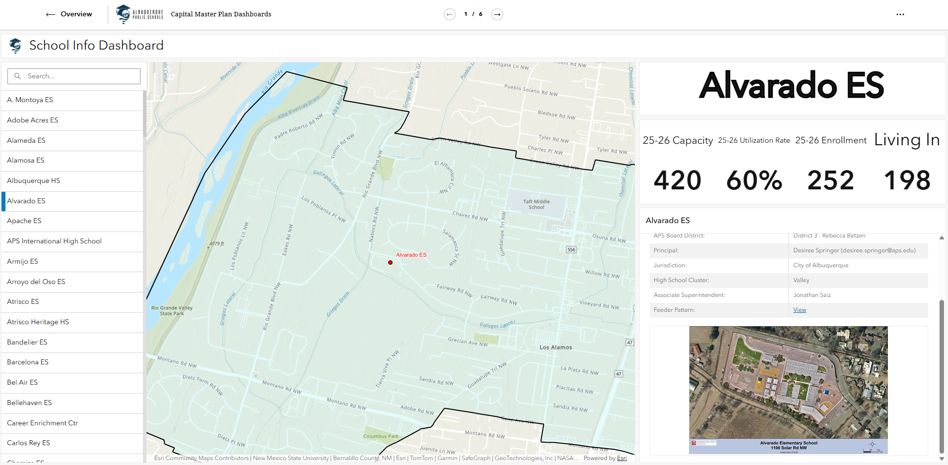
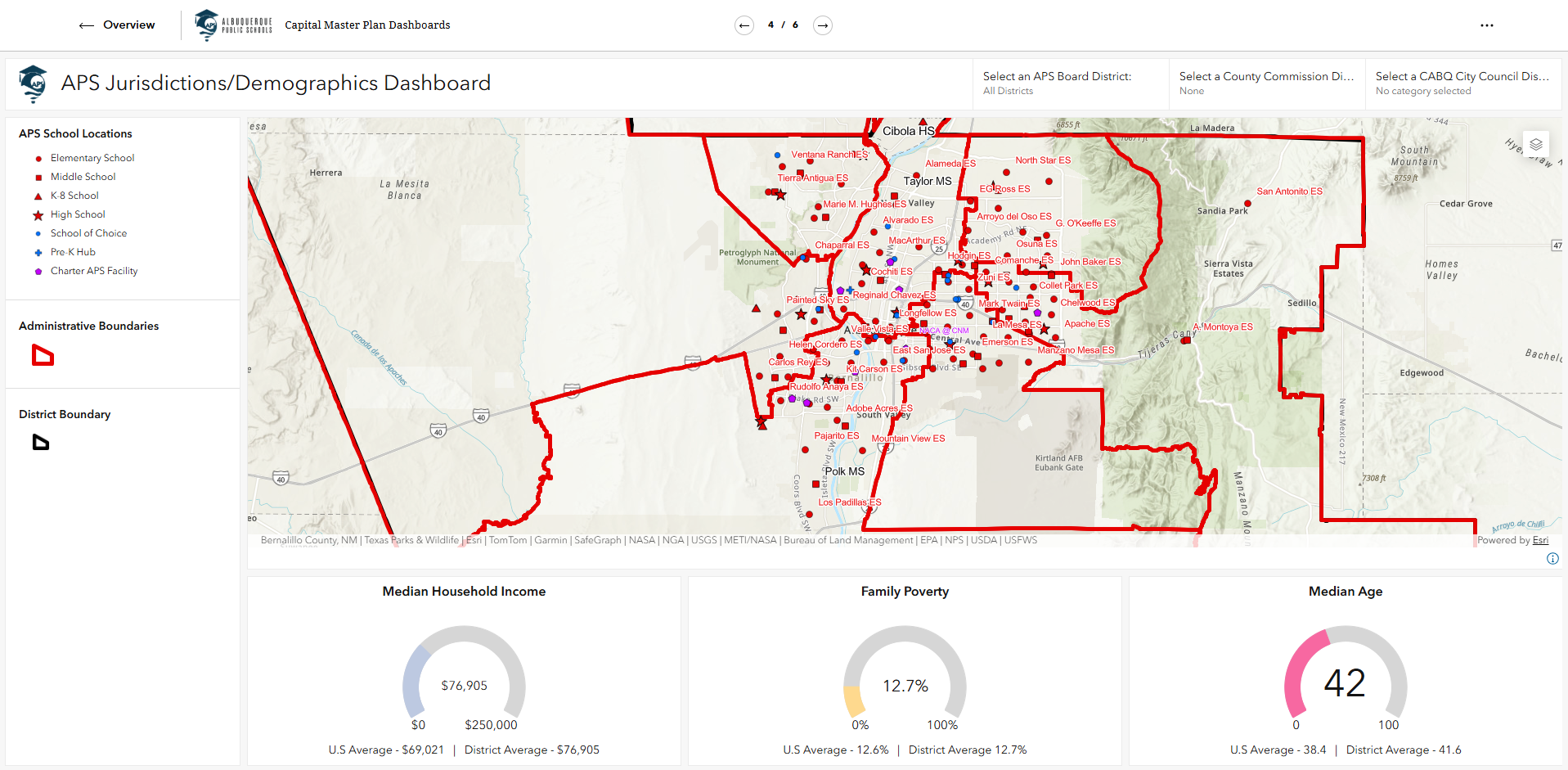
The Feeder Pattern dashboard allows a community member or parent to see exactly which elementary, middle, and high schools feed into and out of one another, so they can make informed decisions about their educational needs. The Demographics dashboard highlights key community attributes in a simple, easy-to-use interface. Using simple map navigation, users can learn about their neighborhoods' income characteristics, median age, and family poverty levels. These are important considerations in planning processes, which is why it is important to be able to communicate the data driving district planning.
By providing this data on an easy-to-use, mobile-friendly online platform, CMP and APS reaffirm their commitment to public accountability and ensure that all community members, regardless of their location or background, have equitable access to the data that shapes their children's educational environment. With just a few taps on the APS website, all of this data can be accessed, allowing the public to inform themselves about the data used in decision-making processes. Keeping the public informed is fundamental to APS's role as an institution and steward of public agency funding.
Optimizing Operations: Internal-Facing Dashboards
The internal APS community comprises teachers, administrators, and district support staff; naturally, CMP has an obligation to provide resources to this organizational community to enhance facility operations. Generally, these dashboards are tailored to a department that has a specific need to both analyze and report its data. In these cases, the base data is provided, such as school locations on a map, and each department can add its own data to a school for display and analysis.
This can be highly useful in district-wide planning for the locations of Pre-K or Special Education programs, for example, where there is a need to ensure that programs are located equitably. These dashboards can also serve to inform the wider community, whether internal or external, by gathering feedback or simply communicating the locations of such programs.
Internal data is categorized into two types: programmatic and facility. Facility data represents the built environment and is most commonly associated with floor plans. Programmatic data represents how the environment is used and is often overlaid on facility data. The connection between these two data sets is inseparable. However, their combined utility is realized only through a dynamic system for accessing floor plan information.
Hence, enabling district-wide, up-to-date, accessible floor plan data has been a key focus of the CMP department. When floor plans are distributed in a controlled manner, programmatic data can be overlaid to better allocate resources and accommodate the programs needed at a given school. Through informative maps and internally developed dashboards, planners analyze facility space and adjust as needed for efficiency, evaluating overall utilization based on enrollment, physical capacity, and program allocations.
These dashboard visualizations depict the efficiency and effectiveness of each school to inform recommendations to schools, such as student transfers, program relocations or consolidations, and capital improvement projects.
By integrating facility and programmatic data into an accessible format for district facilitators, the Capital Master Plan department bridges the gap between technical internal operations and the broader maintenance and operations mission. Internally accessible dashboards provide the necessary insights to understand the direction of the organization’s future. This approach ensures that internal staff gain the granular insights necessary for optimizing school environments, transforming complex facility planning into an intuitive narrative of responsible stewardship and equitable resource allocation.
The New Paradigm: Data Sovereignty and Community Consent
Data sovereignty is the right of a community to govern the collection, ownership, and application of its data. It marks a pivotal shift in the wider planning community and is particularly relevant here, as APS, as an institution, interfaces with both department- and community-authored knowledge. It requires that CMP, when presenting or authoring data, follow established guidelines from the department or community from which the data was obtained and obtain express consent to do so.
APS serves multiple tribal communities throughout its service area, with students coming from Sandia Pueblo, Laguna Pueblo, To'Hajiilee, and Isleta Pueblo. These communities view their data as part of the tribal community's system of knowledge, and thus, their right to data sovereignty is of the utmost importance. APS works closely with our tribal communities to ensure that we protect their data and use it only within the parameters within which it was shared with us.
The CMP department manages the district's ‘Find My School’ application, which functions as an address database that ties each address within the service area to a school. Parents can then see their home school's feeder pattern to inform decisions about their children's educational pathway. Obtaining address data from the Pueblos involved various meetings with tribal leadership, MOUs, and a promise from APS about how these addresses would be used. In return, having all tribal addresses in the system facilitated better access to the district for those living on tribal lands.
The protection of tribal knowledge and addresses is just one example of how APS engages community members and collects data to ultimately better serve the district. CMP also maintains a Vision Zero for Youth Initiative data dashboard, a strategy to eliminate all traffic fatalities and severe injuries while increasing safe, healthy, equitable mobility for all.
The Vision Zero program involves facilitating the creation of walking school buses, in which community members and school staff walk children in the local neighborhood to school. There is extensive community involvement in the walking school bus, but there is also a need for APS to report on how these walking school buses are performing so the district can report back to various stakeholders on how, why, and where funding is being spent.
After receiving feedback from one such community, CMP partnered with the South San Pedro Neighborhood Association to obtain consent to collect walking school bus data in a mutually beneficial way. The collaboration with the South San Pedro Neighborhood Association serves as a key example of data sovereignty in action, in which the community developed the "REFRIED" consent document to provide essential guidelines for institutions engaging with their local knowledge and to inform the development of the Walking School Bus dashboard.
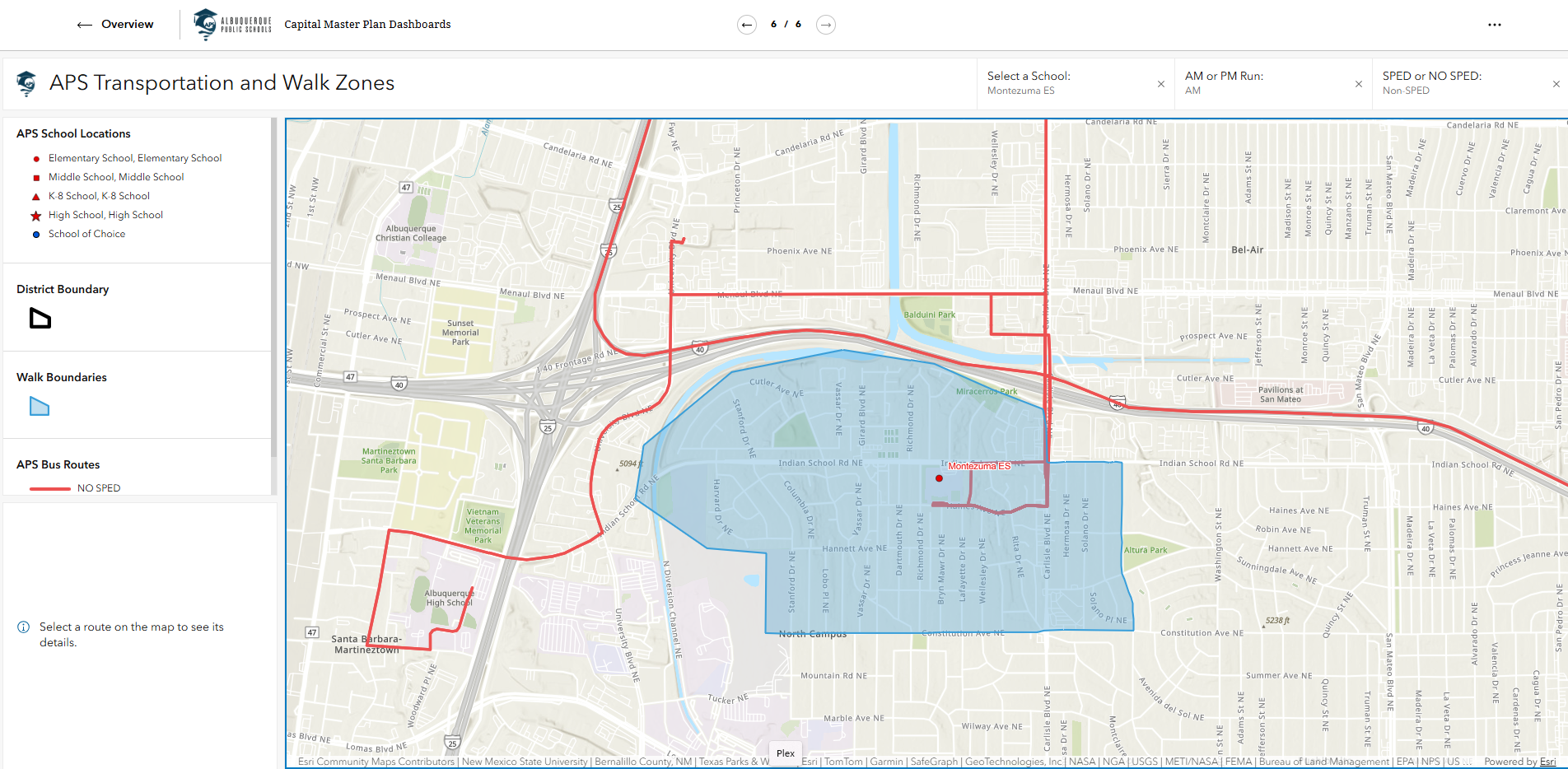
As a result, CMP was able to collect data from communities and present it back to them in the form of a dashboard showing quantitative data on walking school bus attendance and hazards encountered along the way.
With so many stakeholders and communities across the 1,230+ square miles of APS, ensuring that communities have consent and control over their data is key to both data collection and effective communication. APS navigates this complex landscape of data communication by balancing transparency, operational efficiency for internal staff, and respect for community data sovereignty.
This comprehensive strategy, rooted in the foundational pillars of public accountability and collaboration, transforms district-wide planning into an inclusive narrative that honors the rights and knowledge of all stakeholders, particularly tribal and local neighborhood groups.
Summary
In conclusion, the deployment of online GIS dashboards by APS serves as a powerful demonstration of the agency’s commitment to its foundational principles of public accountability and equitable access. By systematically developing forward-facing data for community transparency, tailored internal-facing tools for operational efficiency, and a robust framework for data sovereignty and community consent, APS transforms complex facility planning into an inclusive and ethical practice.
This holistic approach ensures that every stakeholder, from external neighborhood groups to internal staff, is empowered with the knowledge necessary to collaborate in shaping the district's future.
About the Authors
Aron Roberts, APA, NMGIC (aron.roberts@aps.edu) is the GIS (Geographic Information Systems) manager for the Albuquerque Public Schools Capital Master Plan Department. Aron has been with the district since 2019 and leverages spatial analytics to drive strategic school planning and district-wide data management. He further advances these initiatives by integrating drone operations to provide high-resolution aerial mapping and critical site intelligence for the district.
Yvonne Morales, APA, NMGIC (yvonne.morales@aps.edu) is a GIS (Geographic Information Systems) Planner in the Albuquerque Public Schools Capital Master Plan department. Yvonne's focus is converting between CAD and GIS data, enabling various planning processes through spatially aware dashboards such as spatial utilizations, fire evacuation planning, and campus wayfinding. Yvonne has converted over 14 million sq ft of floor plan data across more than 125 school sites as part of the district's roll out of spatially aware floorplans.