
The Complete (Zoning) Picture: Collaboration is Key to Washington’s new online Zoning Atlas
by Dr. Tammi Laninga, Justin Patterson, Tara Newman, Katie Cote
Introduction
What types of middle housing are allowed in different parts of Washington state? Are cities going along with national trends to reduce parking requirements? What types of allowed uses are likely to be impacted by rising sea levels? These questions, and many more, can now be answered using the new interactive Washington Zoning Atlas (WAZA or Atlas) (Figure 1). Funded by the Washington Department of Commerce, the atlas was developed by an innovative collaboration between two private consulting firms (MAKERS architecture and urban design and BHC Consultants), the University of Washington’s Natural Resource Spatial Informatics Group (NRSIG), and urban planning faculty and students at Western Washington University (WWU), Eastern Washington University (EWU), and the University of Washington (UW) Seattle and Tacoma campuses.
In this article, we share the motivation behind the project, key highlights about the atlas’s development and the innovative development team, and lessons learned from the creative collaboration between the parties involved.
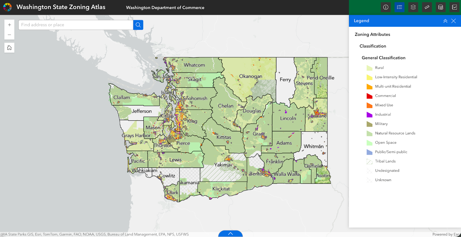
Figure 1: Washington State Zoning Atlas showing zoning codes statewide (source: screenshot from Washington Department of Commerce online Washington Zoning Atlas).
Why an Online Atlas?
Zoning codes fundamentally shape how communities grow, impact who has access to housing, and what kinds of development are possible. However, zoning information is often inaccessible, fragmented, and difficult to analyze or compare across jurisdictions. Furthermore, over the twentieth century, there has been a loss of spatial logic associated with zoning. As Emily Talen argues, with the “gradual wearing down of the connection between place, character, and rule, … zoning schemes became a seemingly random, ad hoc distribution of zones” (2012, p. 57). The WAZA not only makes zoning more accessible; by visualizing it, viewers can examine the logic of patterns created by zoning.
The Washington State Zoning Atlas (WAZA), partially modeled after the National Zoning Atlas (NZA), converts local zoning codes into standardized, geospatial datasets that can be used to compare jurisdictions easily in map format. The WAZA builds on and extends the Washington Department of Commerce’s Puget Sound Mapping project, which was developed to show growth patterns around the Puget Sound Region using consistent methods across cities and counties (Washington Department of Commerce, 2025a). Learning from this experience, Commerce, with funding from the state legislature, set out to create the statewide zoning atlas.
Commerce’s goal for the atlas is to visualize zoning across the state and examine the effectiveness of several amendments to Washington’s 1990 Growth Management Act (GMA). The GMA requires all cities and counties to designate and plan for resource lands and critical areas. The fastest-growing cities and counties must also adopt comprehensive plans and development regulations that guide future growth (Municipal Research Services Center, 2025). In recent years, the GMA was amended by adding new housing, climate change, and transit-oriented development requirements:
HB 1337 requires jurisdictions to allow two ADUs on all residential lots (Washington Department of Commerce, 2025b).
E2SHB 1110 requires minimum densities for middle housing in most residential areas, including those zoned for single-family (Butler, 2023).
HB 1181 requires jurisdictions to add a climate change and resiliency element to their comprehensive plans and to include sub-elements for greenhouse gas emissions reduction and for resiliency (Pool, 2023).
HB 1491 requires cities to designate “station areas” around certain public transit stops for higher-density development. It defines rail and bus station areas and amends the definition of a “major transit stop” (Bauer, 2025).
The atlas can be used to study where barriers to housing may exist and how new housing laws apply and are being implemented across the state. “It also supports environmental, ecological and economic research by clarifying where development is likely to happen and how intensive it may be” (Washington Department of Commerce, July 24, 2025). Figure 2 illustrates how the atlas can be used to look at development patterns that combine attributes like use, height, and density to show where different building forms are allowed.
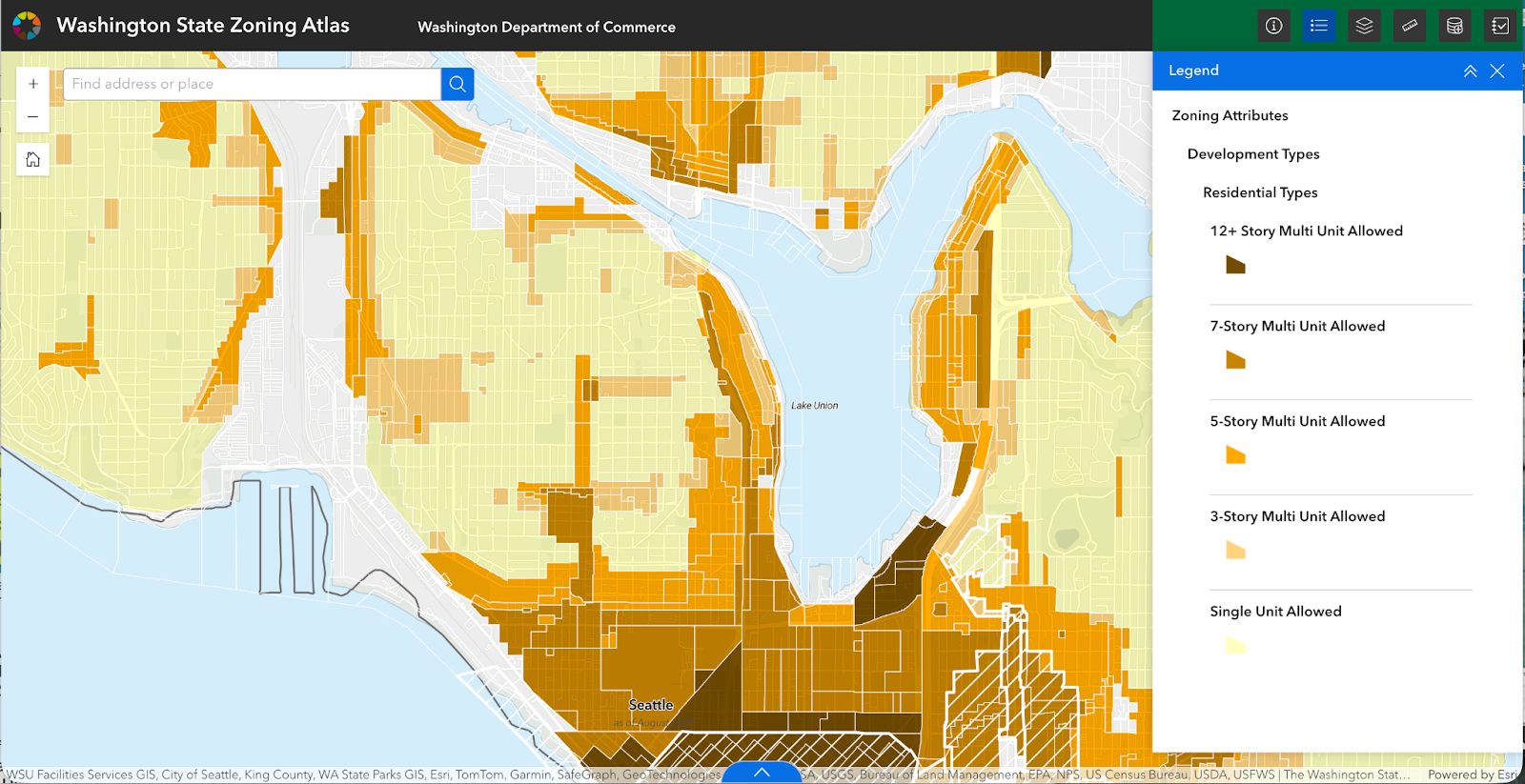
Figure 2: Zoomed in look at the “development types” layer that combines attributes such as use, height, and density (source: screenshot from Washington Department of Commerce online Washington Zoning Atlas).
Along with the atlas, Commerce has developed several resources including a WAZA User Guide, a fact sheet called “How Could I Use the Atlas?,” and a link to the WAZA datasets (Washington Department of Commerce, 2025c).
Innovative WAZA Development Team
The development team brought together planners from Commerce, the private sector, and universities. The fall 2023 Request for Proposal (RFP) was timely. The state’s three accredited planning programs at WWU, EWU, and UW had started the University Planning Collaborative in response to state funding provided to each program to support comprehensive plan updates in cities and counties around the state. Planning faculty had connected with planning consultants employed at MAKERS and BHC at the American Planning Association Washington Chapter’s annual conference the same fall. When Commerce posted the RFP, MAKERS’ senior planning staff pulled together representatives from BHC, the UW’s Natural Resource Spatial Informatics Group (NRSIG), and the universities to write the proposal. The team was awarded the contract.
The consultants brought to the table their extensive experience with zoning code development for many Washington jurisdictions. The research scientists at the University of Washington’s NRSIG brought their expertise from past geospatial projects that visualized data like agricultural land in Washington and the Washington Public Land Inventory (NRSIG, 2025). Planning faculty contributed their research and teaching expertise in land use zoning and geographic information systems (GIS) to collect zoning codes, digitize paper zoning maps, and develop a cross-university training seminar. Finally, urban planning students from the four universities brought their genuine interest and problem-solving skills to collect and analyze zoning codes from 320 jurisdictions across the state. Table 1 shows the project team and their contributions to the WAZA project.
| Tasks | Project Team | Months |
|---|---|---|
| Populate Advisory Group | MAKERS, Commerce | 1–2 |
| Initial Database Set-up | MAKERS, BHC, NRSIG | 2–4 |
| Refine Zoning Classifications for Data Standardization | MAKERS, BHC, NRSIG, Advisory Group | 3–5 |
| Develop Student Analyst Guidance | MAKERS, BHC, NRSIG, Student Liaison (UW Graduate Student), Universities | 3–5 |
| Deliver Training Curriculum | WWU Faculty & BHC | 4–6 |
| Collect and Standardize Data | Student Liaison, students, MAKERS, BHC, Commerce | 6–15 |
| Clean Data | MAKERS, NRSIG | 12–16 |
| Data Governance and Maintenance Plan | MAKERS, BHC, Commerce | 16–18 |
| Publish Atlas | NRSIG, Commerce, MAKERS, Student Liaison | 17–18 |
Atlas Development Highlights
The WAZA took eighteen months to build. The public source tool is built with ESRI’s ArcGIS Online and includes three layers:
Zones – land use attributes
Overlays – zones overlaid onto the base zoning district to alter or supplement the underlying regulations
Jurisdictions – city and county boundaries developed from the US Census Tiger line files.
Creating the tool required extensive data collection to visualize zoning attributes from nearly all of the state’s 320 jurisdictions. Students from Washington’s university planning programs were pivotal in this labor-intensive component of the project. In spring 2024, thirty students attended a first-of-its kind multi-university online urban planning course, taught by Dr. Laninga, with assistance from UW graduate student and student liaison to the project, Justin Patterson. The seminar provided an overview of comprehensive planning and land use zoning in Washington state. Guest speakers included Growth Management Services director Dave Anderson, members of the MAKERS and BHC consulting teams, and research scientists from NRSIG. Students were organized into teams based on their schools. Their first task was collecting zoning codes and maps. Their second task was to pilot the data entry process developed by NRSIG using the analyst guidance prepared by MAKERS. To test inter-coder reliability, students paired up and input data for the same jurisdiction. The project team compared results and revised the data entry guidance and methods accordingly. From the original cohort of thirty, nine were hired as data analysts during summer 2024.
Student analysts had two methods for inputting zoning attributes. Method 1 was using the zoning attribute data collection “web experience” online portal. Method 2 was through the zoning attribute data collection web map through ArcGIS Pro. Most analysts selected Method 2, as it provided an easier path to enter multiple data points. Data entry time per jurisdiction varied significantly based on the complexity of its code. Smaller towns, and those with simpler codes, could be completed in 1-2 hours. Larger cities, or those with more complex codes, required up to 10 hours.
Members of the project team met with the Advisory Board six times during the atlas development to discuss everything from code standardization to brainstorming uses for the compiled data. Bi-weekly meetings, and a project MS Teams Channel, kept the team moving forward by developing best practices for standardizing and inputting zoning attributes, addressing questions about unique and/or complicated zoning codes, technical issues with the data entry portal, and more. Final data collection ended in March 2025, with over 95% of jurisdictions’ data being input into the online portal. The final months of the project were led by NRSIG researchers as the focus moved to publishing the online atlas.
Figure 3 is a zoomed-in image of the atlas showing specific zone classifications. The classifications visible on the legend include rural, low intensity residential, multi-unit residential. Additional classifications, which are visible in the map, include mixed-use, commercial. industrial, military, natural resource lands, open space, public/semi-public, tribal lands, and undesignated/unknown.
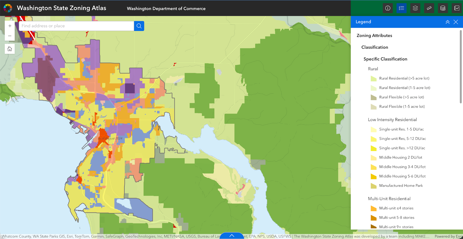
Figure 3: Specific Zone Classifications for a zoomed in area of Washington State (source: screenshot from Washington Department of Commerce online Washington Zoning Atlas).
Project Benefits – for the Public and Project Team
There are three key benefits to the online WAZA, which include:
Helping policymakers, planners, researchers, and local governments track zoning trends.
Providing general information about what uses, and development types are allowed in different jurisdictions across the state.
Supporting studies that connect zoning to other factors, such as housing supply, environmental goals, or economic trends.
The WAZA highlights many aspects of zoning, with a focus on residential and mixed-use development. It also includes valuable information about natural resource lands, green energy sites, industrial areas, and other special uses. All of the attributes included in the database are described in the user guide, which can be found on Commerce’s website.
Another outcome is the networking and skill development opportunities that grew out of the project. For example, some members of the team now serve as advisors on university planning program boards. Consultants see the value in working with students and better understand curriculum requirements that include paid internships and unpaid projects and theses that enable students to earn credit while conducting research. Student analysts networked with professionals and students at other universities, gained experience on a real-world project, and honed skills in reading and interpreting zoning codes.
Finally, for some communities, the atlas is the first time they have seen their zoning represented online. Many smaller communities do not have a digitized version of their zoning code. The atlas is a resource they can use to view their zoning map and some zoning attributes in real-time and plan for future revisions as they identify ways to comply with new GMA requirements.
Lessons Learned & Limitations
The work of the collaborative team that developed the WAZA project resulted in a final published map, and many opportunities, as outlined above. But it also had its challenges.
Grant Administration across Private and Public Partners: The private sector has “time and expense” billing, universities have direct and indirect costs. And each university had its own financial rules and processes that made it hard to navigate. Communicating across these different entities was burdensome for both parties.
University Firewalls and Family Educational Rights and Privacy Act (FERPA): Students not enrolled in a university cannot access university resources like course management systems. Faculty cannot share student contact information across universities. Creative, and less than optimal, methods for sharing course materials and student grades were required.
Collaborating across Private/Public Sector: Unique logins and passwords had to be set up for all project members to ensure access to the online data collection portal and MS Teams site. Logistical and technical issues created access challenges for consultants, researchers, and student analysts.
Zoning Data is a Snapshot in Time: The WAZA reflects data collected and standardized by Commerce and the team from April 2024 to June 2025. Some data may be inaccurate or incomplete. With quality checks, the team did their best to ensure accuracy, but this project occurred during a major update cycle for all Washington cities and counties planning under the GMA, which will translate to many changes to zoning codes in coming years.
Keeping the Atlas Updated
The Data Governance and Maintenance Plan outlines several actions that will need to be taken to retain the atlas’s utility. These include capturing newly adopted zoning, error correction, and general improvements. There are different approaches to making updates, which the Department of Commerce will need to adopt moving forward. Table 2 shows the approaches along with their pros and cons.
| Approach | Pro | Con |
|---|---|---|
| Rolling (preferred): Jurisdictions notify Commerce about zoning changes within 60 days of the change and Commerce updates the atlas |
|
|
| Periodic: Every 5 years with Comprehensive Plan requirements |
|
|
| Opportunistic: As possible when funding is available |
|
|
(source: Data Governance and Maintenance Plan, 2025)
Conclusion
With the publication of the WAZA, zoning data in Washington has become more accessible. As one student analyst reflected, “Something that surprised me about zoning ... was how ambiguous some of the codes were. It was hard to fully understand what some of the codes meant. Zoning codes should be user friendly and accessible to everyone to ensure effective uses.” The Department of Commerce’s new Washington Zoning Atlas has done just that – made it possible for anyone to view current zoning within individual jurisdictions, and across the whole state.
References
Bauer, L. (2025, August 5). 2025 Legislation Affecting Local Government Planning. Municipal Research Services Center. https://mrsc.org/stay-informed/mrsc-insight/august-2025/2025-planning-legislation.
Butler, S. (2023, July 19). Major Changes to Washington’s Housing Laws. Municipal Research Services Center. https://mrsc.org/stay-informed/mrsc-insight/july-2023/major-changes-to-washington-housing-laws.
Land Use Atlas, Inc. (2021-2025). National Zoning Atlas.
Municipal Research Services Center. (2025). Growth Management Act Basics.
https://mrsc.org/explore-topics/planning/gma/growth-management-act-basics.
Natural Resource Spatial Informatics Group. (2025). Projects.
Pool, L. (2023, July 27). New Legislation Related to Climate and the Natural Environment. Municipal Research Services Center.
https://mrsc.org/stay-informed/mrsc-insight/july-2023/new-legislation-climate-natural-environment.
Talen, E. (2012). City Rules: How Regulations Affect Urban Form. Island Press: Washington, D.C.
Washington Department of Commerce. (2025, July 24). Commerce launches statewide Washington Zoning Atlas to support smarter planning. Enterprise Wire.
https://www.einpresswire.com/article/833448096/commerce-launches-statewide-washington-state-zoning-atlas-to-support-smarter-planning.
Washington Department of Commerce. (2025a). Puget Sound Mapping Project.
https://www.commerce.wa.gov/growth-management/data-research/ps-mapping/.
Washington Department of Commerce. (2025b). Accessory Dwelling Units.
https://www.commerce.wa.gov/growth-management/housing-planning/adus/.
Washington Department of Commerce. (2025c). Washington State Zoning Atlas.
https://www.commerce.wa.gov/growth-management/data-research/waza/.
About the Authors
Dr. Tammi Laninga, Western Washington University, Urban and Environmental Planning & Policy Department; Justin Patterson, Pierce County Office of Resilience and Climate Action (former University of Washington Master of Urban Planning graduate student); Tara Newman, Washington Department of Commerce; Katie Cote, BHC Consultants.