
Five Planning Ideas for the Oregon Coast Trail
by Cole Grisham, AICP

Image 1: Oswald West State Park. Source: Oregon Parks and Recreation Department
The Oregon Coast Trail (OCT) parallels all 362-miles of the Oregon coast. Sections of the trail are on federal lands or connect to federal trails. While maps depict a complete route and the OCT was declared “hikeable” in 1988, to make connections between accessible beaches and developed trails, portions of the OCT follow the shoulder of US 101 or follow local roads. Indeed, some portions may not be accessible at high tide either. Some of these portions are unsafe and many hikers opt for a car, shuttle, or public transportation to make connections instead; other hikers skip these sections entirely. So, calling the trail as hikeable throughout is not exactly accurate.
To address the OCT gaps, a project team composed of local, state, and federal agencies are partnering to develop a long-term action plan for the entirety of the OCT. As of Spring 2021, the project is still in its infancy so there are still considerable opportunities to craft what such an Action Plan might look like. In this article, I describe the project’s history followed by five planning ideas for the development and long-term management of the OCT based on the local, state, and federal project team’s work.
Project History
The OCT recent project history can be thought of in three acts. The first is the Oregon Coast Trail Connections Strategy, developed by the Oregon Parks and Recreation Department in 2011. This project divided the entirety of the coast into ten high-level sections for analysis, including stakeholder workshops and identifying possible future trail alignments. As Figure 1 shows for one trail section, the Strategy provides possible short-term and long-term primary or secondary alignments. The Strategy was a great first step at getting stakeholders together and identifying possible futures, but seems to not have had legs after completion.
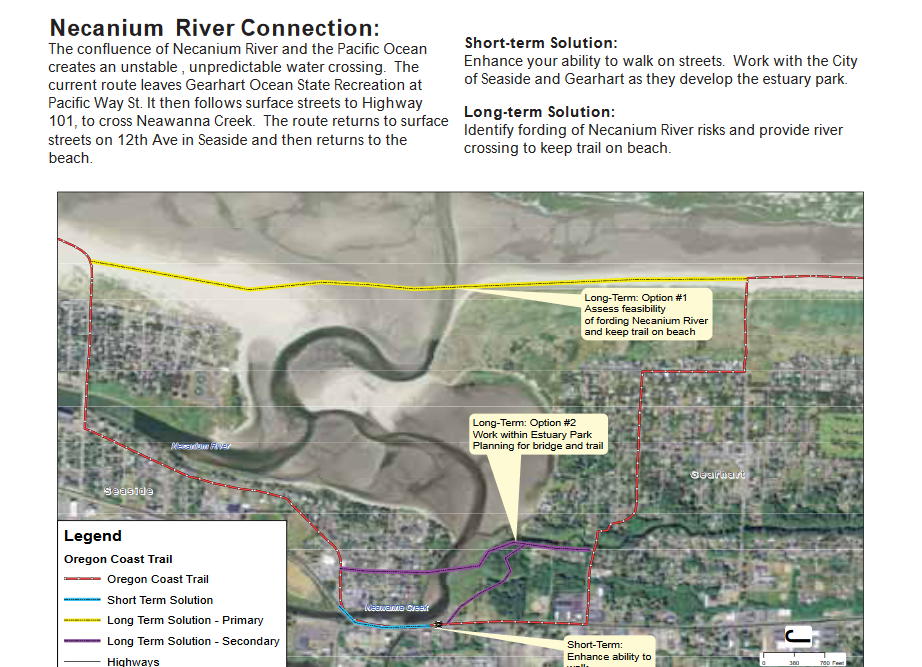
Figure 1. Example Connections Strategy recommendation for one section of the Oregon Coast Trail. Oregon Coast Trail: Connections Strategy (2011)
The second is a mixture of Oregon’s Governor and Legislative prioritizing completion of the OCT. in 2017, the Oregon Legislature directed OPRD to complete an Action Plan in collaboration with the Oregon Department of Transportation, state and local agencies, nonprofits, and other stakeholders. The Action Plan must address:
Preferred options for the development, maintenance, and operation of each new trail gap, including related costs that:
Accounts for existing uses of the land where trail segments are to be constructed, including public highway right-of-way, private or public ownership and active rail use
Ensures that the designation of trail segments will not conflict with surrounding private property rights, including rights of way and easements
Considers the concerns of the public and other interested parties
Prioritization of new trail segment construction based on resulting improved safety, immediacy of implementation, potential project sponsors, and sources of funding
Potential sources of funding for implementation of the plan, including but not limited to federal, state and private sources
Options for designation of final state agency or other responsible entities for the development, maintenance, and operation of the trail and trail facilities as identified in the plan.
From there, Governor Kate Brown designated the Oregon Coast Trail as an Oregon Solutions priority project that would develop a long-term governance structure for the OCT. This designation allows for (1) a State Representative and Parks Commissioner to co-convene stakeholders from along the coast to (2) work with the Oregon Solutions staff out of Portland State University on a long-term governance system. The Connections Strategy, coupled with Legislative and Governor direction, has elevated the OCT completion in the eyes of Oregon planners, which the final act may be able to address.
The final (and current act) is the Federal Lands Access Program (FLAP) project to develop an Action Plan. In 2018, a collection of Oregon agencies led by the Association of Oregon Counties (AOC) applied to FHWA’s Western Federal Lands office for funding to support collaborative governance work and Action Plan development. FLAP funding is meant for projects on or adjacent to federal lands such as the OCT, which ribbons near and through US Forest Service and US Fish and Wildlife lands throughout the length of the coast. OPRD was ultimately awarded the FLAP grant as one of the primary trail facility owners, with AOC, Oregon Solutions, and Western Federal Lands partnering. While some work started in 2019, the pandemic stalled nearly all work for a variety of reasons. In late 2020, Western Federal Lands, OPRD, AOC, and Oregon Solutions jointly reinitiated the OCT Action Plan work. In the remaining sections, I therefore outline five ideas this multi-agency team are focusing on going forward (not necessarily in order).
Five Planning Ideas
1. Start with Collaboration
Both the planning for and actual construction of the OCT includes multiple, often overlapping jurisdictions. Coordinating actions between these jurisdictions is necessary to complete a cohesive trail network. This means that the Action Plan must begin from a foundation of working together rather than any one agency developing policy for the OCT entirety. To that end, the project scope was jointly developed and is managed by Western Federal Lands, OPRD, AOC, and Oregon Solutions together. The collaboration between these four groups combines the outside perspective of Western Federal Lands with the land owner’s perspective of OPRD and local agencies as well as the governance facilitation of Oregon Solutions.
From there, stakeholder collaboration will occur at several levels. First, the project team is forming a technical advisory group composed of state and local agency staff to guide the scope and direction of the Action Plan. Second, AOC will lead specific trail connection group discussions. Lastly, Oregon Solutions will facilitate long term trail governance discussions with the OCT land owners. These engagements are in addition to a broader public involvement strategy to be managed by OPRD.
2. Map the Connections with the Community
The OCT Action Plan must include trail alignments that meet the needs and interests of the communities they serve. To ensure this outcome, the project team will use a variety of dynamic mapping tools for each connection discussion. In a way, readers can think of the project team’s role as moving the mouse while the community discusses and decides where the best trail alignment should be in their community. To help these discussion, the project team will use innovative mapping tools like the National Digital Trails tool, which allows for on-the-spot weighting and mapping of trail segments based on community preferences. Using tools like this, the project team can learn what communities value in for their trail network, quickly visualize what those preferences would look like during the discussion, and continue refining and adjusting in-meeting.
3. Remember: A Trail is not just for Recreation…

Image 2. View from Samuel H. Boardman State Scenic Corridor. Source: Oregon Parks and Recreation Department
When most people think of the OCT, they think of its recreation uses. Indeed, I have hiked portions of the OCT on vacation most of my life. But at its most basic level, a trail system is a transportation facility, which means its use is a derived demand for reaching a destination. While that may be accessing a scenic view point in one trail segment, it may also be a part of the local road network within a coastal town in another. The Action Plan must therefore address how portions of the OCT form and support the wider transportation system within and between the coastal communities they serve. This ensures any future trail segment recognizes its multiple users and how they vary across the OCT entirety.
4. Who will Manage the Trail Long-Term?
A central motivation for Oregon’s Governor designating the OCT an Oregon Solutions priority was to ensure the trail is managed as a regional asset long term. The OCT Action Plan should provide a set of trail alignments and actionable strategies for future construction, but the trail should also have clear segment owners and managers in perpetuity. While one response may be ‘if it runs through city land, it’s the cities responsibility (or through county land, the counties responsibility, and so on), right?’
Not exactly. It’s possible for one agency to have title to the trail segment (own it) and another have maintenance responsibility. It’s also possible for an existing or future private or non-profit group to maintain portions of the trail. So, it’s imperative that these long-term governance questions are addressed up front and with the entire trail system in mind. To that end, Oregon Solutions will lead this portion of the Action Plan, bringing together the trail land owners throughout to discuss ownership and management issues. The result will be a formal agreement between members on long term governance, consistent with Oregon Solutions collaborative governance process.
5. Focus on a Trail that gets Built
The last idea may seem obvious, but it should be emphasized over and over: focus on a trail that gets built. A common challenge in planning generally is developing very nice plans that end up on a shelf and are never touched again. Indeed, planners themselves often beat their heads against a wall trying to get their colleagues to learn from and implement the recommendations found in the adopted plans. I think the problem is less about whether people are referencing the plan or not and more about whether the plan has anything to say about the post-plan decisions communities and policy makers need to make.
To address this, the OCT Action Plan recommendations should provide a clear hand off to post-plan decision makers. That means providing final trail alignments, conceptual drawings for trail segments, identifying environmental, right of way, and geological issues that will need to be addressed, and future design and construction cost estimates. This information should also be packaged in such a way that the individual land owners can quickly move the information from the Action Plan into a project funding application without doing additional work. This enables the Action Plan to be an actual tool for what comes after plan development: project funding, design, and construction.
Conclusion
None of these ideas or approaches are revolutionary, I don’t think, but that’s also not the point. Instead, the challenge of developing a coordinated plan for completing the OCT has been in those two qualifying words: coordination and completion. How can a diverse set of land owners and interested groups coordinate their actions in a way that leads to a single set of strategies for an entire trail system? How do those strategies move from ideas on paper to a constructed facility in the communities they serve? To address these two questions, I believe we must start with collaboration, map the new trails with and in the communities, they serve, ensure the meets the transportation needs of its communities, and ensure the trail has clear ownership over the long term. If we can address these issues through the Action Plan, I believe we will be well positioned complete the Oregon Coast Trail.

Image 3. View from Cape Sebastian, Looking South. Source: Oregon Parks and Recreation Department
Resources
FHWA’s Oregon Coast Trail Action Plan website: https://highways.dot.gov/federal-lands/projects/or/oregon-coast-trail-action-plan
Oregon Solutions Oregon Coast Trail website: https://orsolutions.org/osproject/oregon-coast-trail
About the Author
Cole Grisham, AICP is a Transportation Systems Planner for the Western Federal Lands Highway Division.